
Long, long time ago, I can still remember...
In 2007, Tod from the Sacramento Meetup Group started scheduling Tahoe Rim Trail hikes, two weeks apart, with the goal of finishing the trail. I had already lost weight and had started a healthier lifestyle, with hiking being a primary tool for getting fit. In my experience, it started to become a healthy cycle: I wanted to do progressively more difficult hikes, but in order to do so, I needed to be better fit. By doing more difficult hikes, I was becoming better fit.
Another thing I strongly believe in is having well defined goals, short term and long. I always try to be working towards something, and the Tahoe Rim Trail fit the bill.
That isn't to say I was fit. I believe the term would be fitter. Certainly, I had lost weight, and in the process, become healthier and fitter than I was before. The thing is, I did no physical activity prior to getting started, so the reference point was small.
To say I had a tough time of it would be an understatement. While I've since hiked the entire Tahoe Rim Trail, my first time on this segment was only my second TRT hike. I was capable of hiking 23 miles at once, but wow, was it ever difficult.
Not so this time around.


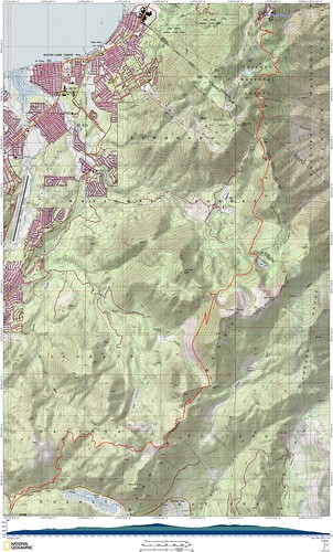
Miles 1 to 5
Of all the odd places to start a hike, this one began underneath a ski lift at Heavenly Ski Resort. In fact, it didn't even start on a trail, it looked more like a 4x4 trail. On further inspection, it was obvious that we were hiking on the ski run.

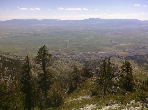
As a ski run, of course, it was pretty steep. As with most sections of the Tahoe Rim Trail, it begins pretty steep until it gets up to the rim, then becomes a steady up & down the rest of the way until the final descent. About 3 miles in, we hit our first heavy sun exposure, and an amazing view of the Carson Valley.
We had plenty of time to see this view, being greeted by about 20 switchbacks, all leading straight up, with full exposure to the sun. We were still pretty close to Heavenly as well, because we could see the power lines that keep the ski lifts running.
At the top of the switchbacks, Tom, the person in the lead, told me to go ahead and pass him if I wanted. I took the opportunity and decided to just push the pace for as long as I could.
Miles 5 to 10
This was the first real indicator that I was in much better shape than I was the first time around. I increased my pace to about 3mph, and felt fine as I hiked along. From time to time I would look behind me, and most of the group except for one or two people were far behind. A few times I even stopped to let them catch up, then moved forward at my previous pace.
By now, the trail had more or less leveled off, and with exception of a few hills, was a pretty easy portion. A few people on bikes passed us going the same direction we were, while a few runners approached in the opposite. One girl was running with a dog, a hydration pack, but nothing else for gear.
At approximately 10 miles in, we reached Star Lake.
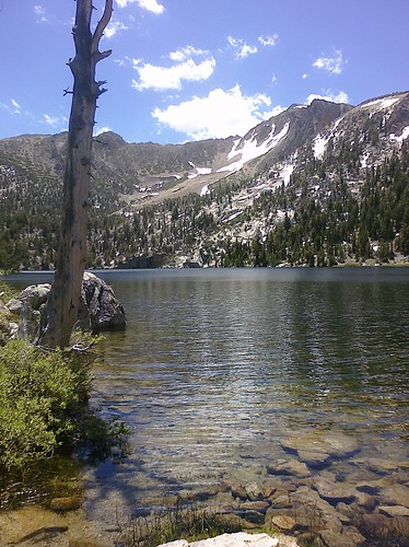
Star Lake
Star Lake was one of the highlights of the entire Tahoe Rim Trail on my first time on this segment three years ago. It has plenty of shore for a lunch spot, yet it's far enough in so the people you meet there are serious about the trail.
When the other people in our group arrived, they told me we were going at a pretty good clip. This made me happy! Seriously, a few of the people were those I had hiked with before, who at that time had been far ahead of me on the trail. For them to tell me we were going fast confirmed that I had improved.
The bike riders who had passed us earlier were taking their lunch here as well, and we talked for some time with them about the trail. The speed record for the TRT came up, and one of the riders commented that the record holder for the Pacific Crest Trail was averaging 40 miles per day. I still think there's a speed you reach where you're busier finishing the trail than you are absorbing the scenery.
The time we'd allocated prior for lunch was 30 minutes, but we arrived 20 minutes before the projected time. We ended up spending more like 45 minutes there, chatting, and doing hiking chores like eating, pumping water, pouring scree out of our boots. Fun stuff.
Once we were satisfied with our rest, we went on our way.
Miles 10 to 15
Almost immediately after leaving Star Lake, we hit more serious elevation gain, which in turn slowed the progress. While the going was slow, I still felt great, without near the fatigue I experienced years before.
At one point, I left the trail to use the bathroom, and felt good enough to jog to catch up with everyone else. The tiredness I felt was more general soreness in my feet instead of my legs.
A hiker came towards us wearing a khaki jumpsuit that looked somewhat like this:

I said, "I didn't know the Dharma Initiative had a presence out here!" He didn't get the reference, and gave me a confused look. At least I tried, right?
Miles 15 to 20
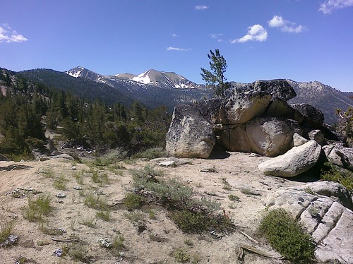
I realize my mileages are off, since I'm just going from memory, but around mile 15 we reached the trail that led up to Freel Peak, a spot I'd just been hiking in the week before. Someone we met on the trail agreed to take our picture as a group.

One person had originally planned to hike to the top of Freel Peak and back, but wisely chose to stick with the group. We still had almost 10 miles to go, and by avoiding the peak, she was able to finish the hike strong.
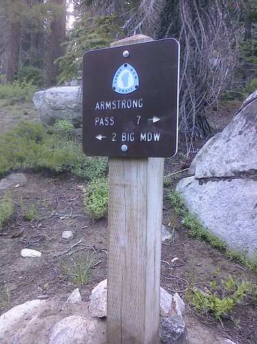
Armstrong Pass provided another resting point. Again, this was a spot we had been at the week before, only this time we were headed the opposite direction on the trail. We were heading into the homestretch.
Just as fatigue was starting to set in, and we were all whining and complaining about how we were ready to leave the trail, we reached another part of the trail I remembered fondly. In fact, on my original hike of this segment, I was barely able to stay on my feet, and the sight of this hill kept me going. This time, it was just a welcome sight and memory.

There was a hill of which the trail went straight through, covered with all sorts of yellow, purple, red, and white wildflowers. On the original hike, you could smell the aroma of the flowers on the approach, but this time, it was more visual. Nonetheless, it was without a doubt the best part of the trail.

The trail led around the hill, leaving at least 1/10 of a mile or more of color. Mike, the organizer of the Meetup group, mentioned that this would be a great beginner day hike, going from the Big Meadow end of the trail to the hill, making a much easier, 8-mile round trip hike. I strongly agree!
Mile 20 to Mile 23
Just past the flower-covered hill, the remainder of the hike flattened into several meadows.

Even though it was flat, it was easily the longest part of the trail! We were tired, grumpy, and after 12 hours, mighty hungry. I vividly remember this part of the trail as a race with the darkness in my prior hike. I had a headlamp, but the people hiking with me before were worried we wouldn't make it back before dark.
Once again, not so this time. Was I tired? Absolutely, but I didn't feel like I was about to drop, or fall asleep on my feet. I was tempted to jog the rest of the trail to make it go faster, but knew it was best not to.
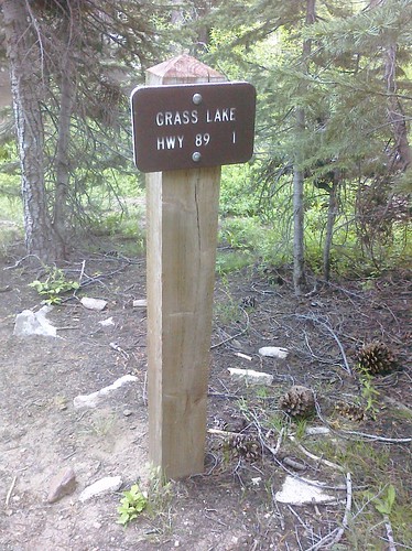
In 2007, with the darkness threatening, we reached a fork in the trail that I found pretty unique. One direction went 2 miles to Big Meadow.
While the other went 1 mile to the highway.
The leader of the hike in 2007 made the executive decision to take the 1-mile path to the highway, then let the others pick us up later. At the time, I was extremely upset at the decision, but I could still understand why it had to be done. I was also extremely tired, and wasn't in the mood to argue.
Of course, this time around, we took the 2-mile route, and the sadistic trail makers started taunting us. The trail wound around within view of the highway, giving us the false sense that we were finishing. On occasion, the trail would wind around and go the opposite direction of the highway, then wind back and head towards it. Each time, we thought it was time to finish, and I swear, this had to be the trail makers' intent.
In the end, I was tired, but not completely exhausted. We still had 45 minutes before it was completely dark. We ate the rest of our food while waiting for the car shuttles to pick us up, and at 9pm, we were ready for the drive back to Sacramento.
See the activity on RunSaturday
| Type: | Cross - Other |
| Duration: | 12:21:36 |
| Distance: | 22.83 mi |


