
Today was another great run! Once again traffic wasn't cooperative. It has to be my timing coming up and going down the overpasses, but I always end up with 20 cars going onto the freeway whenever I need to cross! So I have to stop for sometimes 30 seconds or more for them, it sucks. At any rate, my pace was exactly the same as the other day, and my time was one second faster. And to top it off, I didn't feel like I did yesterday, which is great, hehe.
Most interestingly, the HRM and the GPS were IDENTICAL for calories burned: 690. I have no idea how that happened, the GPS is time & distance only. I suppose it's accurate at this point.
So anyway, 5.5 miles, 52 minutes, 690 calories burned.
Friday, September 12, 2008
Hey guys, I finally got around to trying out geotagging. It took some serious research to find the tools! It's still obscure for some reason.
A quick bit of background, part of the reason I took my Canon 10D with me on the last segment of the Tahoe Rim Trail was geotagging. I wanted to get the process down so when I take my trip to Mt. Whitney, I can have the pictures, with the GPS track, geotagged in Flickr, and mapped onto Google Earth. I haven't taken it to Google Earth yet.
So anyway, I took the pictures, and have the resulting jpegs in a folder. You can do this with the RAW files, but since I already had the jpegs on Flickr, I started there.
After lots of research I found a program called Geosetter. It works WONDERFULLY. When I put the .gpx file into the same folder as the images, once I clicked on the folder holding the images, it knew to use that file. It then was able to interpolate the data based on EXIF dates, and finally save the GPS data to the EXIF of the images.
Finally, I replaced the images already on Flickr with the updated ones. The process would have been a lot quicker had they not already been on Flickr, I could have just done one upload. You do need to tell Flickr that yes, you want to automatically map EXIF information.
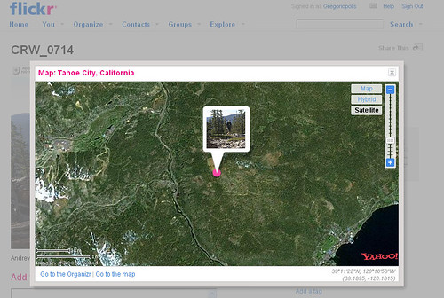
Once I did that, the images were mapped within Flickr. Each image shows its city location, and a link to Map, which when clicked, shows the image on a map. Since this was backcountry hiking, I had to turn on the Satellite map. Here's a sample:
The rest of the images from that hike are here.
I apologize for not all the files being geotagged, but the images not taken by me didn't have timestamps. It seemed to work out pretty well! Not being a Picasa user, I'm not sure how it handles the images, but Flickr seemed to work out well.
I'll be geotagging a lot more images, as well as doing it for all the pictures from my upcoming Mt. Whitney trip.
A quick bit of background, part of the reason I took my Canon 10D with me on the last segment of the Tahoe Rim Trail was geotagging. I wanted to get the process down so when I take my trip to Mt. Whitney, I can have the pictures, with the GPS track, geotagged in Flickr, and mapped onto Google Earth. I haven't taken it to Google Earth yet.
So anyway, I took the pictures, and have the resulting jpegs in a folder. You can do this with the RAW files, but since I already had the jpegs on Flickr, I started there.
After lots of research I found a program called Geosetter. It works WONDERFULLY. When I put the .gpx file into the same folder as the images, once I clicked on the folder holding the images, it knew to use that file. It then was able to interpolate the data based on EXIF dates, and finally save the GPS data to the EXIF of the images.
Finally, I replaced the images already on Flickr with the updated ones. The process would have been a lot quicker had they not already been on Flickr, I could have just done one upload. You do need to tell Flickr that yes, you want to automatically map EXIF information.
Once I did that, the images were mapped within Flickr. Each image shows its city location, and a link to Map, which when clicked, shows the image on a map. Since this was backcountry hiking, I had to turn on the Satellite map. Here's a sample:
The rest of the images from that hike are here.
I apologize for not all the files being geotagged, but the images not taken by me didn't have timestamps. It seemed to work out pretty well! Not being a Picasa user, I'm not sure how it handles the images, but Flickr seemed to work out well.
I'll be geotagging a lot more images, as well as doing it for all the pictures from my upcoming Mt. Whitney trip.
Subscribe to:
Posts (Atom)


