
When I started today's run I expected it to be great. It was cloudy, sprinkling here and there, but overall a nice day. It didn't quite turn out the way I planned. I started out going way too fast (8:27/mi), which hurt me in the end. By 4 miles, I had to walk for about 1/8 of a mile. The rest of the run was a lot slower.
Splits were:
Mile 1: 8:24.78
Mile 2: 8:42.48
Mile 3: 9:21.95
Mile 4: 10:45.92
Mile 5: 11:48.02
Mile 6: 10:26 (.35 mile)
Total Time: 52:37.74, Distance: 5.35 miles, Calories Burned: 665, Pace: 9:51
Tomorrow's my long run. Fun, fun, fun!
Friday, October 31, 2008
Running Vlog #1
About a week ago I made my first running vlog, and thought I had deleted it mistakenly (as opposed to saving it). Come to find out, I had it stored on a different memory card. So here it is.
I know, I seem dorky in the video. When I do a new one it'll be better, I promise. I'm only using my Treo 755p, which is why the quality is low. Still, it's neat to have.
I know, I seem dorky in the video. When I do a new one it'll be better, I promise. I'm only using my Treo 755p, which is why the quality is low. Still, it's neat to have.
Thursday, October 30, 2008
Today was supposed to be a gym day, but it didn't quite work out that way since Tim decided he wanted to run again. This time, he wanted to do 3 miles, so we ran my 5k route. It's the same as the route we ran yesterday, going partway through the route a second time to catch the extra distance.
He did the same thing again, too. I was slowing down for him, but he kept speeding up. When we got to the 2.5-mile mark, he sped up from 10 min/mi to 8.5, and a half-mile later, he was exhausted. I think we ended 3.1 at 11. I burned about 400 calories, which isn't too bad. It was kind of nice running shorter two days in a row, although a bit weird.
Meanwhile, someone from the Tivo Community Forum turned me onto some software called SportTracks. While comparable to the Garmin Training Center, in many ways it's better. It even tracks equipment, so the next time I buy some shoes, it'll come in handy.
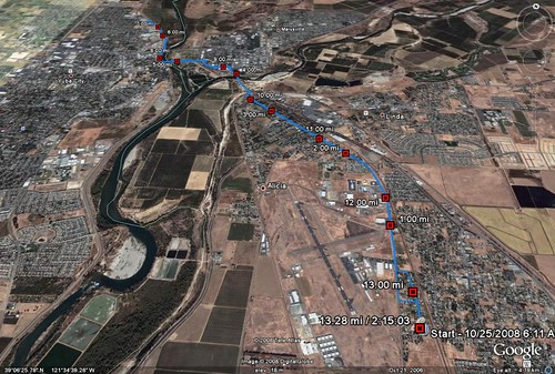
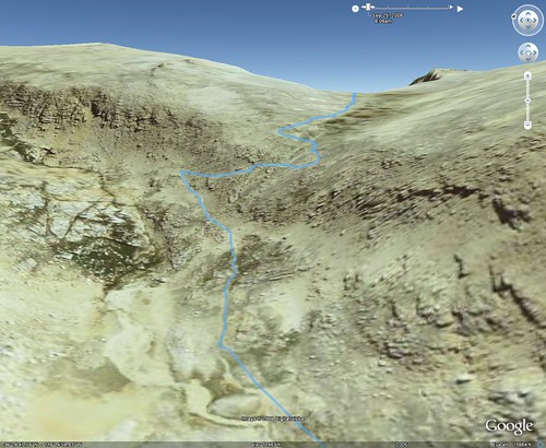
What's even cooler is its output to Google Earth is much better. While the Garmin software shows every point along the route, SportTracks will put just the splits if you want. Here's an example, from my Saturday long run:
Needless to say, I'm pretty happy with it.
He did the same thing again, too. I was slowing down for him, but he kept speeding up. When we got to the 2.5-mile mark, he sped up from 10 min/mi to 8.5, and a half-mile later, he was exhausted. I think we ended 3.1 at 11. I burned about 400 calories, which isn't too bad. It was kind of nice running shorter two days in a row, although a bit weird.
Meanwhile, someone from the Tivo Community Forum turned me onto some software called SportTracks. While comparable to the Garmin Training Center, in many ways it's better. It even tracks equipment, so the next time I buy some shoes, it'll come in handy.
What's even cooler is its output to Google Earth is much better. While the Garmin software shows every point along the route, SportTracks will put just the splits if you want. Here's an example, from my Saturday long run:
Needless to say, I'm pretty happy with it.
Wednesday, October 29, 2008
I introduced my coworker to the wonderful world of running this afternoon. We ran 2 1/2 miles; I think he was a bit too gung ho, as he told me to set a pace and he'd try to keep up. I kept it around 10 min/mi, and he kept it up but was really showing his difficulties at about a mile and a half. I kept offering to slow down or to walk, but he would have none of it. He was surprised when we rounded the corner back towards home, saying whoa, we're almost there? I said yeah, we hit two miles a bit ago. Then he ran as fast as he could to the finish. The end pace was around 8:30. It was fun, now he wants to do three.
So in the end I burned 300 calories, which isn't too bad. Not as many as I normally do, but I'll still take 'em.

So in the end I burned 300 calories, which isn't too bad. Not as many as I normally do, but I'll still take 'em.
Tuesday, October 28, 2008
Today was certainly an off day. I put off going to the gym as long as possible, and when I got there, I just wasn't exerting myself enough. So in 30 minutes, I only burned about 100 calories. I suppose it wasn't a total waste, since I did get some exercise in, but man. Now I need to be sure and make up for it tonight on the stairclimber, which I still haven't used in months.
And to top it off, this morning on the way to work I had not one, but TWO buttermilk bars (donuts). Holy cow, I'm stupid.
Tomorrow.
And to top it off, this morning on the way to work I had not one, but TWO buttermilk bars (donuts). Holy cow, I'm stupid.
Tomorrow.
Monday, October 27, 2008
My normal weekday route, 5.35 miles. After the great Saturday long run, I decided to have a great Monday. I just decided to keep my pace around 9.00/mi, and set out to maintain it. I came close.
Mile 1: 8:42
Mile 2: 8:48
Mile 3: 9:04
Mile 4: 8:59
Mile 5: 9:19
Average Pace: 9:00/mi (woo!)
Average HR: 164bpm (boo!)
Calories Burned: 672
Mile 1: 8:42
Mile 2: 8:48
Mile 3: 9:04
Mile 4: 8:59
Mile 5: 9:19
Average Pace: 9:00/mi (woo!)
Average HR: 164bpm (boo!)
Calories Burned: 672
Saturday, October 25, 2008
This morning, my breakfast was split so I'd be able to eat before, during, & after this morning's long run.
Before:
Oatmeal: 320
Banana: 109
During:
Gel: 110
After:
Pria Bar: 170
Pancakes: 150
Total: 689
Keep in mind though, this is MUCH more calories than I normally have. If I was sitting on my butt this morning I would have eaten more like 200.
So the long run... same route as last week, same distance, 13.3 miles. Remember earlier in the week I turned auto laps every mile? So now I have splits.
I ran it differently this week and it made a HUGE difference. Remember last week I talked about my calves burning? That didn't happen. I ate a banana before I ran, which likely made a difference. The biggest difference though is that I watched my pace closely early on and kept it strictly at 10 min/mi or slower, and let it dip down to 11 a couple times. As a result, my time was MUCH better than last week. More importantly, I feel great. I'm not exhausted like I was, and have virtually no soreness.
After the halfway point I stepped it up a tiny bit and ran faster, but came to a dead stop when four dogs came out of the trees, barking like crazy. They were obviously not attacking me, but I was still cautious. I walked slowly until they gave up, that's all I needed, having neighborhood dogs chasing me. Even pets can bite on occasion. Once they gave up on me, I started again.
Unlike last Saturday, the last two miles weren't bad at all. In fact, when I got to the Furneaux Rd. sign a mile from my house, I said out loud, "Take THAT, Furneaux!" Last week that was the sign that I just felt MISERABLE at.
Mile 1: 10:04
Mile 2: 10:07
Mile 3: 10:25
Mile 4:10:46
Mile 5: 10:42
Mile 6: 10:09
Mile 7: 10:57
Mile 8: 10:52
Mile 9: 9:32
Mile 10: 10:03
Mile 11: 9:11
Mile 12: 9:33
Mile 13: 9:58
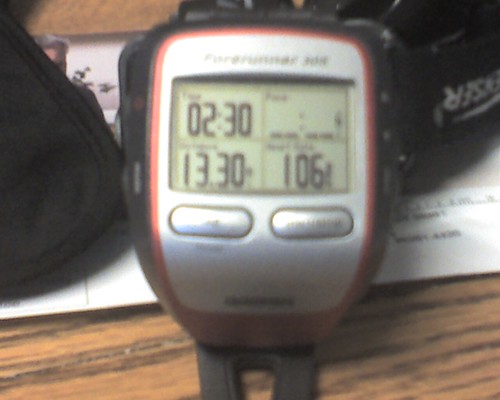
I don't have the mile splits for last week but it's obvious what they looked like. My average pace then was 11:19/mi, THIS week's average was 10:09. Last week I finished in 2:30, this week was 2:15. If I keep working on it, by the time I run my first real half marathon, I just might break 2 hours!
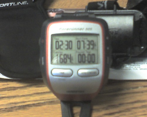
Oh, and on the Garmin 305, the heart rate strap, and how it calculates, I think I just proved it's using the heart rate in calculations. Calories burned were 1689, and last week's was 1684. Almost the same number, even though I was 15 minutes faster. I think that throws my whole time/distance theory out the window. :)
Empirical data GOOD. Fire BAD.
Before:
Oatmeal: 320
Banana: 109
During:
Gel: 110
After:
Pria Bar: 170
Pancakes: 150
Total: 689
Keep in mind though, this is MUCH more calories than I normally have. If I was sitting on my butt this morning I would have eaten more like 200.
So the long run... same route as last week, same distance, 13.3 miles. Remember earlier in the week I turned auto laps every mile? So now I have splits.
I ran it differently this week and it made a HUGE difference. Remember last week I talked about my calves burning? That didn't happen. I ate a banana before I ran, which likely made a difference. The biggest difference though is that I watched my pace closely early on and kept it strictly at 10 min/mi or slower, and let it dip down to 11 a couple times. As a result, my time was MUCH better than last week. More importantly, I feel great. I'm not exhausted like I was, and have virtually no soreness.
After the halfway point I stepped it up a tiny bit and ran faster, but came to a dead stop when four dogs came out of the trees, barking like crazy. They were obviously not attacking me, but I was still cautious. I walked slowly until they gave up, that's all I needed, having neighborhood dogs chasing me. Even pets can bite on occasion. Once they gave up on me, I started again.
Unlike last Saturday, the last two miles weren't bad at all. In fact, when I got to the Furneaux Rd. sign a mile from my house, I said out loud, "Take THAT, Furneaux!" Last week that was the sign that I just felt MISERABLE at.
Mile 1: 10:04
Mile 2: 10:07
Mile 3: 10:25
Mile 4:10:46
Mile 5: 10:42
Mile 6: 10:09
Mile 7: 10:57
Mile 8: 10:52
Mile 9: 9:32
Mile 10: 10:03
Mile 11: 9:11
Mile 12: 9:33
Mile 13: 9:58
I don't have the mile splits for last week but it's obvious what they looked like. My average pace then was 11:19/mi, THIS week's average was 10:09. Last week I finished in 2:30, this week was 2:15. If I keep working on it, by the time I run my first real half marathon, I just might break 2 hours!
Oh, and on the Garmin 305, the heart rate strap, and how it calculates, I think I just proved it's using the heart rate in calculations. Calories burned were 1689, and last week's was 1684. Almost the same number, even though I was 15 minutes faster. I think that throws my whole time/distance theory out the window. :)
Empirical data GOOD. Fire BAD.
Wednesday, October 22, 2008
Today I ran 5.35 miles again. My usual route, although I was a bit faster overall. I think though that I need to slow down in the earlier miles so I can be a bit faster in the later ones. Here's the splits:
Mile 1: 9:13
Mile 2: 9:18
Mile 3: 9:39
Mile 4: 10:07
Mile 5: 10:19
Average: 9:43/mi
Total Time: 52:03
Calories Burned: 675
And that's another thing. The Garmin's HRM isn't varying much run to run, so I'm starting to think it's still only going by time & distance. What I should do is wear it and drive 5 miles at 5mph and see what it reads then. Heh.
Monday, October 20, 2008
Well, this is interesting.
Saturday morning, I did the 13.3 miles.
Sunday I did nothing, I barely walked to the bathroom all day, and watched a lot of TV.
Today I ran 5 miles. I felt GREAT! I was expecting to still be a little sore, maybe a little slower, but nope. My heart rate was where it needed to be, I was faster than I was the previous week, and I'm in a great mood now.
Why did I feel so much better? Was it being exhausted after my Saturday run, and then the rest? I'm happy it's this way, but it's totally unexpected.
I also changed the settings on the Garmin to auto-lap every mile, so I now have my splits down (times for each individual mile):
Mile 1, 9:39
Mile 2, 9:50
Mile 3, 10:33
Mile 4, 10:09
Mile 5, 9:49
Mile 6*, 9:22
Mile 6 was only .35 of a mile. 5.35 miles, 53:15, 9:57/mi average. 673 calories burned.
Saturday, October 18, 2008
I was successful waking up early this morning! I was actually able to eat breakfast and get out the door by 6am. My first long run in, well, a long time. More than a month. I blame the Whitney prep, because instead of doing long runs on Saturdays I was either hiking or backpacking. One became more important than the other for what I was wanting to do.
Anyway, here's the Garmin:
13.3 miles! The longest I've ever run. I felt really good most of the time, but the last mile and half was HARD. Holy cow, my thighs were on fire. I ended up walking a little bit (2 or 3 minutes).
There's also a version of this on MotionBased
Here's something interesting: the applet for uploading data from devices on Garmin Connect has been switched from ActiveX to Flash, and the Flash plugin doesn't support the 305 any longer! It says, "Garmin Connect does not currently support this device." So it sounds like that's why you were unable to upload your runs to Garmin Connect, they changed it.
I stopped twice along the way, once to give directions to a lost truck driver, the other at the midway point to eat some Powerbar Gel. 2:30.40, average pace 11:19/mi. Average heart rate 150, 1684 calories burned.
Friday, October 17, 2008
Today was my lunchtime 5-miler (well, 5.34 miles). I thought I had complained about my heart rate here last week, but it looks like I didn't.
I'd noticed that lately my heart rate was a lot higher than it's been. Whereas before I was 154 to 156 average, lately it's been more like 166 to 170 (my max HR is 182). I was getting a bit worried about it.
On today's run I decided to slow down and instead of running for time or pace, run for heart rate. I tried to keep around 156, which is in the aerobic zone for me.
When I got back, I plugged the GPS into the computer and checked the data. My average was 159, which while not "there", it was a lot closer than 170. Then I compared it to my other runs, and come to find out the reason my heart rate was so high is I was pushing myself a lot more than I should.
What a strange thing. On a running forum I lurk in (can't bring myself to post at this point), they keep telling people, slow down if you're not in the aerobic zone. Over and over, slow down, slow down. Now, comparing the data, there's really no mystery as to why my heart rate was so high: I had to slow down!
The last time I ran this route I did it with 9:33/mi average, and finished at 51:05. My average heart rate was 170 with a max of 207! This time with purposely slowing down, it was 10:19/mi, 159bpm average, and my max was 187. That's quite a difference, and I feel SO much better afterwards.
So lesson learned, I guess. 55:06, 10:19/mi, 677 calories burned.
Thursday, October 16, 2008
Well, I can honestly say that eating BEFORE going to the gym made a difference. Today was great.
Circuit 1
Wide-Grip Lat Pulldowns (drop set), 1-3 reps @ 120lbs, 6 @ 80lbs
Medium-Underhand-Grip Pulldowns, 15 reps @ 80lbs, then hold midpoint until failure (32 secs)
Seated Hamstring Curls, 15 reps @ 80lbs
Jumping Lunges, 10 reps on each leg
Hill Run, 1 min, incline 12, 8.5mph
Circuit 2
Terry Pulls (pyramid up with weight), 20 @ 20lbs, 12 @ 30lbs, 6 @ 40lbs
Back Kicks w/Shoulder Press, 10 reps each leg (20 total) @ 10lbs
Hill Run, 1 min, incline 12, 8.5mph
Circuit 3
Seated Cable Rows, 3 @ 120lbs, 8 @ 80lbs
Step-ups, 40 reps alternating (20 per leg)
Butt Kicks, 1 min
Circuit 4
Incline Bicep Curls, 10 reps each arm (20 total) @ 20lbs
Pike Crunches, 25 reps
Seated Hamstring Curls, 10 reps each leg (20 total) @ 45lbs
Butt Kicks, 1 min
Circuit 5
Supermans, Hold midpoint for 1 min
Boat Pose, Hold pose for 30 secs
Reverse Plank, Hold 1 min
Jump Rope, 1 min
47 minutes, 200 calories burned
Tuesday, October 14, 2008
WOW.
You'd think that after all this time, I would have learned the lesson that I learned today. I suppose I'd learned this lesson before, but sometimes a repeat is necessary.
Did you know that it's important to eat prior to a workout?
I got light headed on the treadmill while doing sprints today. I'm going to eat lunch now.
Circuit 1
Scorpion Push-ups, 7 reps
Dumbbell Flys on Body Ball w/Crunches, 10 reps @ 25lbs
Leg Extensions (pyramid up with weight), 20 @ 60lbs, 12 @ 80lbs, 6 @ 100lbs
Jump Squats, 20 reps
Circuit 2
Decline Dumbbell Presses, 20 @ 25lbs
V Cable Flys, 15 reps @ 20lbs
Squat Thrusts, 20 reps
Side Lunges, 20 reps alternating (10 ea leg)
Circuit 3
Close-Grip Pushups, 10 reps
Plank-ups, 20 reps
Jump Squats, 20 reps
One-Leg Squats, 10 reps per leg (20 total)
Jumping Jacks, 1 min
Circuit 4
Military Shoulder Press, 8 reps @ 25lbs
Wood Choppers, 15 reps on each side of body @ 80lbs
Knee Tuck Jumps, 10 reps
Static Lunges w/Lateral Shoulder Raise, 10 reps on each leg @ 10lbs
Reverse Crunches, 20 reps
Hanging Abs with a Twist, 10 reps on each side (20 total)
Circuit 5
30-second sprints (5 over 5 mins), nope... 1x30sec [b]FAIL![/b]
Friday, October 10, 2008
I just got back from running, and it's much windier than yesterday. Severe weather alert and everything:
A WIND ADVISORY REMAINS IN EFFECT UNTIL 9 PM PDT THIS EVENING.The nice thing is that I ran with the wind for about half the way. :) 5.34 miles, 9:33 min/mi average, 51:05 (6.3mph). 674 calories burned.
NORTHERLY WINDS HAVE DECREASED TO 10 TO 20 MPH THIS MORNING AND WILL
INCREASE TO 20 TO 30 MPH WITH GUSTS TO 40 MPH BY THIS AFTERNOON AND
CONTINUE INTO THE EARLY EVENING.
Thursday, October 09, 2008
Yesterday would have been my running day, but of course I went and forgot my gym bag. This may be an excuse, but I'm sorry, I'm not running in work shoes, dockers, and a polo shirt. But that's just me.
So today instead of the gym, I ran. Lots of wind, too, gusts are like 25 to 30 mph. It turned out pretty well, 5.33 miles, 52:40, average 9:52/mi (6.1 mph). 675 calories burned.
So today instead of the gym, I ran. Lots of wind, too, gusts are like 25 to 30 mph. It turned out pretty well, 5.33 miles, 52:40, average 9:52/mi (6.1 mph). 675 calories burned.
Monday, October 06, 2008
Back from the gym, and the infamous Jillian Michaels circuits. Bwahhhhh, it's been a while. My body kept SCREAMING to me that it's been a while. Here we go.
Circuit 1
Dumbbell Presses on Body Ball, 20 reps (10 per arm) @ 35lbs
Dumbbell Flys on Body Ball w/Crunches, 1/2 weight of press, 15 reps @ 20lbs
Squats 50 reps fast (no added weight)
Sprint @ 9mph, 1 min
Circuit 2
Plank, 10 secs
Close-Grip Push-ups, 5 reps
Side Planks w/Inner Thigh Raise, 10 reps
Flip Back to Plank, 5 secs
Close-Grip Push-ups, 5 reps
Side Planks w/Inner Thigh Raise, 10 reps
Flip Back to Plank, 5 secs
Burpies, Straight from Plank, 10 reps
Sumo Squats, 50 reps
Sprint @ 9mph, 1 min
Circuit 3
Frog Push-ups, 20 reps (I don't remember them being this hard)
Squat Thrusts, 20 reps
Static Squat, 30 secs
W Shoulder Press w/Leg Extension, 10 reps each leg @ 10lbs
Jump Rope, 1 min
Circuit 4
Bench Dips, 20 reps
Rope Tricep Presses, Until failure, 15 reps @ 40lbs
Static Lunges w/Lateral Shoulder Raise, 10 reps w/each leg forward @ 10lbs
Mountain Climbers, 1 min (2x30sec)
Boat Pose, 30 secs
Circuit 5
Jump Rope, 1 min
Bicycle Crunches,50 reps
Extended Plank, 30 secs
42 minutes, 187 calories burned
Interestingly enough, at Target the other day I noticed that they're now stocking Making the Cut. I've had it for a long time but they have it now. So if anyone's interested in buying the book, it'll be there. :)
Thursday, October 02, 2008
It's taken me a week, but I've finally gotten around to writing a trip report for the last week's (not)Whitney trip. I can't believe how tough it's been to write this! Not putting it into words, but having the time to sit down and write it. Anyway, here we go.
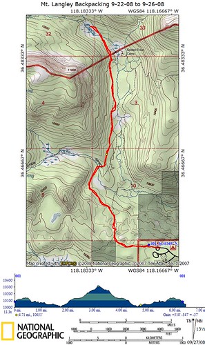
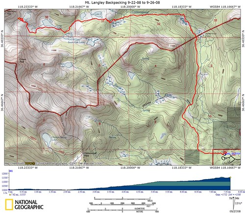
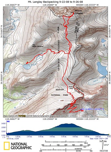
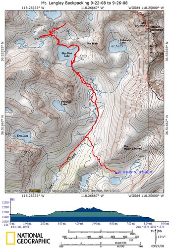
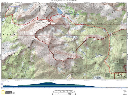
To start, here's a TOPO map of the entire trip. If you click the image, it'll take you to its Flickr page, where you can see the full resolution image (2190x2282).

9-18-08, Day One: Getting There
We had originally wanted to get out of town by 10am, but Rob was busy doing last minute prep. That actually gave Bob and I a chance to pick up some last minute things of our own, so we made it to Rob's house by 11. Rob got home at almost noon and we ate a quick lunch while doing some extra route planning at his house. We also decided to cut the trip short by a day, returning on Friday rather than Saturday. I called the Inyo Reservation Line and had the permits changed.
The drive down was pretty pleasant. We were going to drive through Sacramento to 50, then across to 395, but in Sacramento we changed the plan and drove to Reno, then across. It would have likely been quicker to go Highway 20 to 80, but at that point we were already in Sacramento.
We made an obligatory Starbuck's stop in Reno. I'm not a coffee drinker, but both Bob & Rob are, so it was necessary for them. I understand, that's how I feel about my Diet Mt. Dew. It also gave us a chance to stretch our legs before the 120-mile or so drive ahead of us.
Once in Bridgeport, we fuelled up at this odd gas station that was suspicious of its customers. How do I know this? The picture gives it away.
We ate dinner at a place called Rhino's Bar & Grille. It was already cold outside! I had to dig my fleece out of the pack to get warm. Dinner was great, I had a chef's salad while Rob & Bob shared a steak.
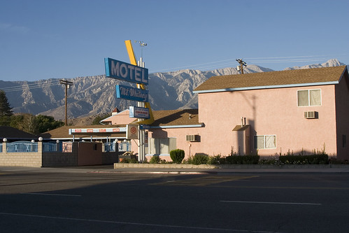
We finally arrived at the motel in Lone Pine at 11:30. The guy at the Motel Mt. Whitney was very friendly and helpful, I don't think I've encountered someone like that in a locally-owned motel like that before. We all took the opportunity to shower and then hit the hay.
9-19-08, Day Two: Breakfast, Campgrounds, and Shuttles - oh, my!
I've been trying to figure out why, when on vacation or traveling I have no problem waking up at 5:30am, while on work days I can't seem to get myself out of bed. On the dot, my body woke up and refused to go back to sleep. I took the opportunity to take a few pictures with my Gorillapod.
When I came back, I quietly opened the door, being careful not to wake anyone up. Unfortunately for me, the sun was directly across from the door, and no amount of carefulness could stop it from blinding Rob. Needless to say, he woke up.
Once up and about, we left our packs and set off to find some food. The guy at the motel office recommended a place called the Alabama Hills Cafe for breakfast. It couldn't have been a better recommendation.
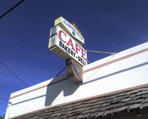
This place had great service, great food, and great prices. They had day-old bread that we were tempted to buy, but skipped on the grounds that we had enough food as it was. I think that was a good idea in the end.

Once fed, we made our way over to the Inyo National Forest Visitor Center & Ranger Station, where we converted our permit registration to real permits. They issued us a real permit, little orange tags to hang on our backpacks while in the Whitney Zone, and Wag Bags. What are wag bags, you ask?
Normally in the backcountry you dig a cathole, a hole 6 inches deep to follow nature's call with. The Whitney Zone is so popular that they've deemed it against National Forest rules to bury waste. You have to pack it out. A wag bag is a large plastic bag full of silicone that, when hit with moisture, turns into a gel. Think of what happens in a diaper, and that's what you have here. You then close up the large plastic bag and put it inside another, zip-close bag, and carry it with you. Yup, you pack out your poop. We also found out at this time that none of our overnight stays would be in the Whitney Zone, otherwise dubbed the Poop Zone.
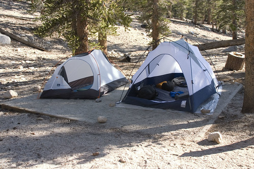
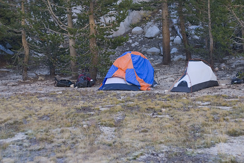
Once we had our permits and were satisfied, we went back to the motel to check out, get our gear, and drive up to the campground. Not having a car with me, and needing someone to stay with our gear while they shuttled the cars, I stayed at the campground. I asked Bob to leave his tent there, so I could put it up and take a quick snooze while they were gone. Little did I know, it would take 3 hours for them to shuttle! So it was a good thing I set up the tent. Once they returned, Rob set his tent up as well.
Rob & Bob wanted to do a quick dayhike to see how far we'd have to hike to get a preview of some of the scenery we were heading towards. We pulled out our daypacks, our Nalgene bottles, and headed out.

We had a snack midway through, and at the Inyo Wilderness Sign (about 3.5 miles), we turned around. The National Geographic TOPO map shows that it was only 6.5 miles total, but the GPS read 7 miles when we got back.
For dinner we took a trial run with our stoves and cooked up soup, Mountain House dinner, and a Mountain House dessert. Everyone was stuffed and satisfied, and Rob had me read some camping-related scripture. That one was tough, I read a passage from James. The only reason was it referenced being in the wilderness. It worked though. Once in bed, I slept pretty well, although during the night I had one of my shout-out-loud dreams. I used the opportunity to walk to the bathroom, and to my surprise, the crescent moon was so bright I didn't need my headlamp. Rob said later that it was 34 degrees that night.
9-20-08, Day Three: Horseshoe Meadow to High Lake, 7.7 mi, +1752'
The next morning we broke camp, made sure everything was cleaned up, put our extra gear & clothes into Rob's car, and headed out. Of course, we had to stop for the obligatory trailhead shot. The Gorillapod came in handy again! If you notice, I'm wearing long sleeves. I brought long sleeve compression shirts, and surprisingly the long sleeves actually helped. Not only did my arms not get sunburned, but they felt cooler because I wasn't feeling the sun directly on them while the air was blowing through the shirt.
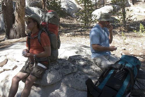
Of course, we had already seen the first 3.5 miles the previous day, so I didn't duplicate the photos. Just after the Inyo sign and just before the main elevation gain, we stopped for a snack.
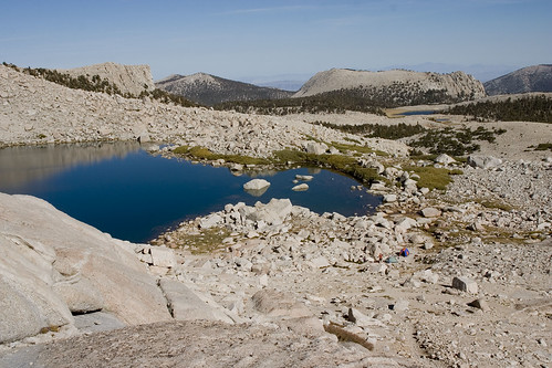
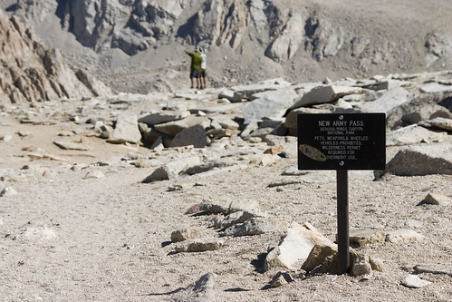
Following the guidebook closely, at every trail junction we followed the signs for New Army Pass. New Army Pass was directly above High Lake, our destination for the day. The first lake we came across was the first of the Cottonwood Lakes, the unoriginally named Cottonwood Lake #1. This was our lunch spot.
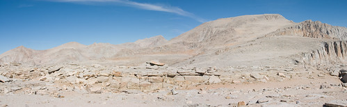
Just beyond the Cottonwood Lakes, we hiked through a boulder field. Those aren't just small rocks, they're boulders the size of trucks.

To give you some idea of their size, Bob is on the left.
After hiking around the Cottonwood Lakes for an hour or so, we came out next to a creek and what looked like the most gorgeous campsite you would ever see. Being about 30 feet from the creek, that eliminated the possibility, but the Forest Service really wanted us to know that we shouldn't camp there. Fine, we won't camp there.

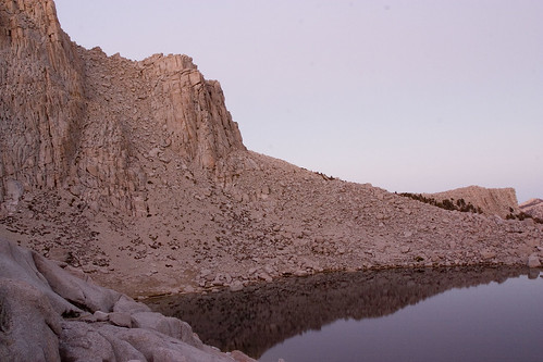
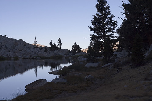
Instead, we camped a bit closer to the lake itself, in a campsite that was much better, in my opinion. There were plenty of rocks for cooking and gear storage, with a nice view of the approach to New Army Pass. Once we got set up, I decided to scope out a good position for some sunset photography. I don't think we could have asked for a better spot.
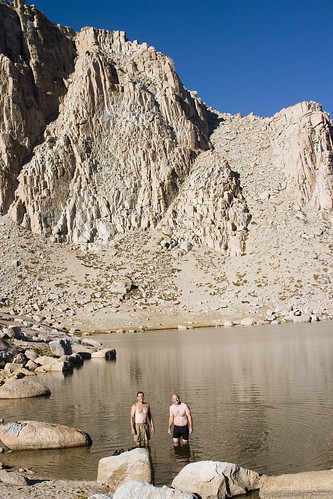
Rob & Bob decided to go for a swim, and called it their "bath". They tried to get me into the water, but that lake was COLD! Rob's watch read 45 degrees.
After the swim, we all ate dinner. As sunset approached, I climbed back onto my perch and took some pictures with the Gorillapod. At $50, barely weighing anything, this was probably my personal favorite gear of the trip. In the past I've carried my normal tripod that weighs at about 8 pounds, so believe me, I was quite thankful for the Gorilla!
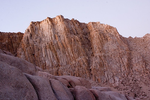
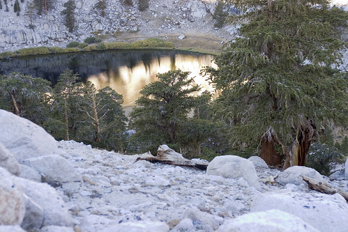
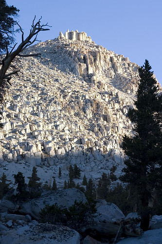
Originally we had wanted to climb Cirque Peak, which we could see from our campsite. Unfortunately, the time we got there and all the camp chores necessary made it something we'd have to save for another time. That's okay. Here's a view of Cirque Peak, at sunset.
Being at over 11,000 feet, combined with lying on my belly to take the pictures really gave my head a good throbbing. I came back down around 8:30pm and pretty much went straight to bed. Rob tried to get me to stay up and visit, but my head just didn't want to cooperate. In the morning, I was extremely happy I went to bed early, since my headache was all but gone.
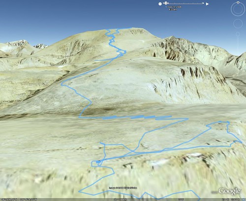
9-21-08, Day Four: High Lake to Mt. Langley to Upper Soldier Lake, 9 miles, +3104'
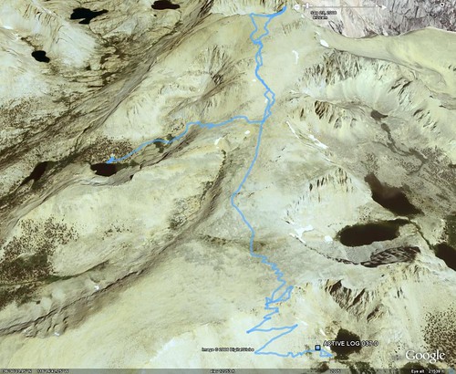
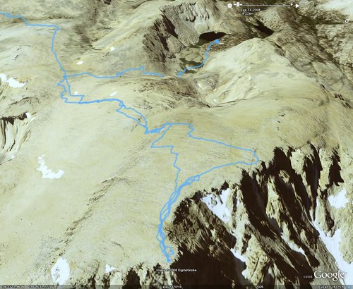
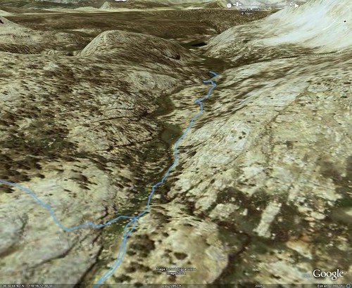
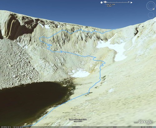
This was the day that really made us start to think that yeah, all the time and effort put into training was coming in handy. Looking at the Google Earth rendering of our trail it's pretty clear: this day was all about the word "uphill".
The elevation gain was really divided in half. The first half was going up New Army Pass.

Heading up the pass, we could see back at our former campsite, High Lake, and the Cottonwood Lakes.
After almost exactly one hour, we made it to the top of the pass.
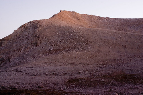
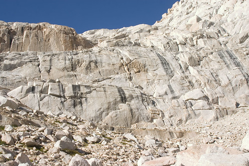
The views were incredible from up there! You could see Mt. Langley, Mt. Muir, Mt. Whitney, and others. Langley was an imposing figure, to be sure. As I found out early on with my Canon 10D, my wide angle lens isn't really all that wide when used on a DSLR with an APS-sized sensor. So what can a guy do? A panorama in Photoshop, of course! Make sure to click on this image, View All Sizes, and view the actual size of this one. Mt. Langley is on the right.
We spent a good half hour exploring New Army Pass. We could easily have spent a few hours up there.
After gearing back up, we headed towards Mt. Langley, which became the second half of our elevation gain for the day.
Per our guidebook, we followed the New Army Pass trail until we saw a wash, which we followed around to a use trail that headed towards Langley. Along the way we came across two fellow hikers who were descending the mountain, and gave us some idea of what to expect. Basically there is no official trail going up to Langley, but there are hundreds of use trails. The use trails get created because really the mountain leading up to the peak is scree, which moves and slides as people walk on it. The trails reminded me of footpaths in slow, coming and going with time. We left our packs behind a large boulder, filled our daypacks with lunch and water, and headed up. I managed to attach the 10D to the pack via a few carbiners, leaving the bag to bounce as I hiked. It wasn't going to be a very long hike, so I figured it'd be okay.
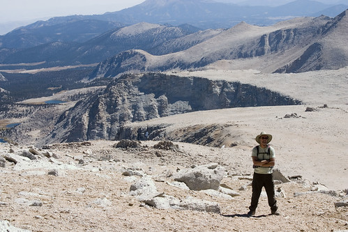
After spending what seemed an eternity climbing up the steep scree slope, we scaled what amounted to 1/4 mile of boulders to reach the summit. Bob found it first, and when we got to the top, he was sitting right on top of the marker. Rob also had to stand on top of the marker, but I was happy with sitting on it.
I set up the camera on the Gorillapod, used the remote trigger, got myself onto the rock and, *SNAP*, we had our hero shot.

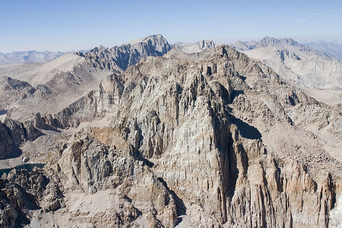
Once again, the views from the top were incredible. From this angle, we could easily see Muir & Whitney, our destination for the next day. Whitney is the highest peak in view.
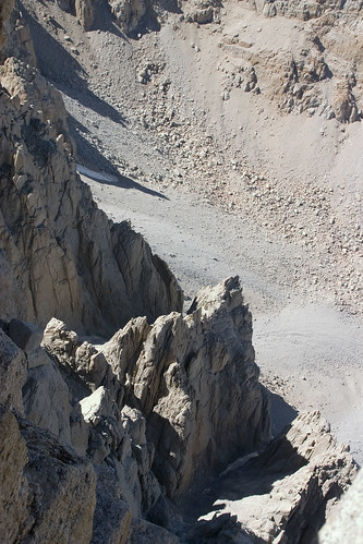
I couldn't resist the temptation and lie down on my stomach, pointing the camera off the edge, for a view down the cliff. This doesn't do it justice.
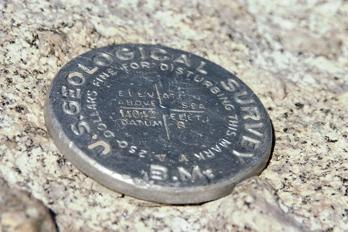
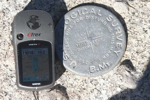
I also couldn't resist this one. I put the GPS next to the marker and took a picture of them together. The Garmin was 28 feet off from the marker's elevation. Which one was inaccurate? Who knows.
Here's a good rendition of our ascent from the opposite (cliff) side of Langley, looking back at the path.
On the way back down, I noticed the camera bag was starting to bounce and hit my legs as I hiked. This was a little strange, since it was supposed to be up by my back, so I adjusted the straps and continued on. At one point Rob was behind me and said hey, your pack's open. Of course, I had zipped it up at the top. What happened was the weight of the camera pulled down, causing the zipper to come undone and just open up. Rob caught it as my cell phone landed on the ground, but guess what was missing from the pack?
The Gorillapod. My favorite piece of gear from the trip had been lost somewhere in the quarter-mile descent from the peak! Using the GPS to backtrack, I had hoped to find it somewhere along the line, but it was obvious once I got back to the peak itself that it was gone. *snif*
Back at the boulder, we took a quick snack & water break, geared back up, and made the descent down to Upper Soldier Lake. Once again, it was a gruelling trip, only this time downhill. According to National Geographic TOPO, the elevation loss was 3404', which was more than our gain for the day.
At Upper Soldier Lake, we were treated to a campsite that was better than even the last one. We were back at a lower elevation, so we had TREES! The lake was surrounded by a beautiful marsh and the site itself could probably have held an entire Boy Scout Troop. It was HUGE, with the Major General imposing above us. There was a wide view of the sky, which once darkness came, was full of stars. The site was so large it was almost like being on a private beach.
We set up camp quickly because we were losing light fast. I filled Rob's bucket with water and we had dinner. This night I stayed up quite a while longer, and we planned the next day, which was to be the day we would summit Whitney. Little did we know, this would not be the case.
9-22-08, Day Five: Upper Soldier Lake to just above Sky Blue Lake to Rock Creek, 8.5 miles, +1370', -1948'
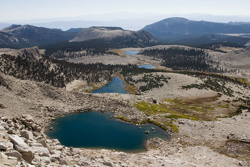
Our morning was an extremely casual one because our goal was to get to Sky Blue Lake, climb the pass, and camp somewhere on the ridge. Mileage was to be short, about the distance of our trip to High Lake, at about 5 or 6 miles. We took our time eating breakfast, and afterwards I took a short hike alongside Upper Soldier Lake for some pictures. At that time of the morning, the lighting combined with the stillness of the lake made for some amazing reflections.
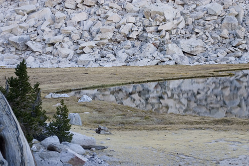
I hiked a little farther and got just above Lower Soldier Lake, which was only about a quarter mile away.
The Major General was impressive from here as well, and the shadows being created by the rising sun was beautiful.
Once our gear was loaded once again, we headed off, this time cross country. Basically we skirted the base of the Major General, then around the side. Once we rounded the bend, we caught a great view.
At the end of the bend, we needed to move towards an "unseen notch". What's an unseen notch? Actually it was just a notch in the landscape that we couldn't see until we were all the way around the bend. We had to climb down some rock and over the creek in order to get over there, where we found a use trail. The trail led up to a small tarn.
It was all beautiful country, but I think of all the areas we visited, the trip through the small canyon in the notch was my favorite.

At a certain point we kept finding what I can only describe as enormous steps. They weren't steps that you could climb, but it's always interesting to me how from a distance you can look at a mountain and see that instead of it being straight up, there are platforms as you travel. This one had probably 3 or 4 of these platforms. This was one of them.
As we hiked across what I described as a platform (really about 1/8 of a mile or so), we hiked along the creek, which was flowing down the length of the platform. Be sure to look at the larger version of this for the detail. Rob & Bob are hiking alongside the creek, which is forming a longish waterfall along the length of the trail.

At the top of this particular platform/shelf (it HAS to have a real name!) was Sky-Blue Lake. It really was blue. Really, really, really blue.
Someone had a tent among the rocks above the lake, so we hiked a bit further and found the perfect place for our lunch break.

Looking back towards the lake's outlet, you can see the dropoff where we climbed in.
Here's another view back to the outlet from the opposite side of Sky-Blue Lake.

Above Sky-Blue Lake, we were following the guidebook's instructions over Crabtree Pass, but things didn't quite add up. We actually had two versions of the guidebook ("Mount Whitney, The Complete Trailhead to Summit guide by Paul Richins"). While I don't have older version handy, I'll quote the new version.
"From Sky-Blue Lake's outlet, walk around the right (east and north) side and ascend alongside the lake's inlet stream, heading generally northwest and then angling west through beautiful meadows and past several small ponds. At a large glacial moraine and two potholes at 11,920 feet, the stream turns right (north). Follow the streambed over large boulders and talus to a tarn at 12,000 feet. At the upper end of this tarn and meadow, hike northeast up gradual terrain to the outlet of the large unnamed lake at 12,129 feet. From the outlet you can look down on Sky-Blue Lake and up to Crabtree Pass."
Right. We walked around the right side and ascended the inlet stream. We stayed northwest, then angled west. Our elevation changed, and we got to around 11,850 feet, but there was nothing. We were below 12,000 feet but certanly didn't see where there could be a tarn. Rob was telling us that we needed to ascend up back where we came from, so we headed back down a bit.
Back at our last turn, this was the only alternate route, not to the pass, but up to where we could see the pass.
If it looks like a cliff, that's because it is. We thought that maybe, just maybe, there was a trail leading up, so we dropped our packs while Bob went ahead to check it out. He started hiking, but as Rob and I watched, we saw him get down on all fours and start climbing. Bob wasn't wearing a pack and was still having some difficulty getting up.
There was no way Richins was talking about this! This was a cliff, but his wording never mentioned that word. In fact, earlier in the text he says, "It is an enjoyable hike to the pass, but it is over difficult terrain requiring a considerable amount of scrambling." Scrambling? Do you call this scrambling? Did he perhaps have a different defition of the word "scrambling"?
When Bob came down, he described it as high Class 2, maybe low Class 3. By the end of the trip he was calling it Class 4. In the end, we had to retreat and head towards Rock Creek, because we were losing light. Not only that, but we had lost the chance to summit Whitney the next day, and needed to make up as much mileage as we could to shorten the trip back the way we came, back to Rob's car. Shuttling Bob's truck to the Whitney Portal ended up being unnecessary. We made it to a good campsite just as the sun was setting. We had dinner, got lots of recovery drink and made it to bed after pouring over maps and the guidebooks. In the end, we all agreed that the place we were at before turning back towards the cliff was really the way we needed to go, and we were probably 2/10 of a mile from where we wanted to be. Hindsight is always everything, of course.
9-23-08, Day Six: Rock Creek to Army Pass to Horseshoe Meadow, 12 miles, +1721', -2345'
The next morning we awoke to frost on everything. My red backpack was reduced to a lame pink color seen through the frost.
The sun was slow at first, so Bob & Rob decided to climb to the sunlight to use the restroom. They ended up ascending what looked to be 70 or 80 feet! It was on the opposite side of the creek and up the hill.
The hike from Rock Creek down to the Army Pass Trail was pretty flat and much welcomed by me. Once we got close to the trail though, we started losing elevation quickly. On the Army Pass trail, we quickly gained the elevation back and then some as we approached the pass.
Once at the top of the pass it was much windier than New Army Pass had been the previous day. We could see New Army from where we were at, but when we came over the top, we saw our trail down. Army Pass is an unmaintained trail that's been bashed and beaten by rockslides for many, many years. And we were going down it!
Somehow I ended up leading the way. I refused to take pictures on the way down, I wanted to be focused on the task at hand.
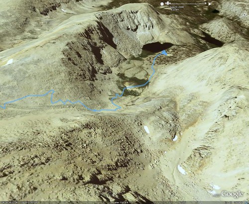
Once at the the bottom we ran into an older gentleman on his way up. He didn't seem too worried about the pass, but we told him how it was for us anyway. I took a picture from our lunch spot, back up towards where we came down. Oddly enough, the angle's pretty close to the Google Earth image.
That lake is Cottonwood Lake #5, with its unique name and neat landscaping.
The trail led between #5 and #4, which came into view next.
Almost at Cottonwood Lake #1, where we had lunch on the first day, Bob told us to look back at where we came. We had a great alternate view of Mt. Langley with a meadow and lake in the foreground.
From here it was a pretty basic hike back, although as I've mentioned before I suffered from the "end of hike" thing where the last few miles seem to take forever. I'm sure it's 100% psychological, but here's something interesting: at one point we barely started to gain elevation when my heart rate jumped to the levels I'm at when I'm jogging. I'm talking 156 to 160bpm. I'm thinking it was simple fatigue, but it affected me quite heftily.
Back at Rob's car we fenagled our equipment and ourselves in and were making plans to shower and have a nice dinner, then a good night's sleep before heading home. Life, as always, had other plans.
When we got into cell phone range and were able to call the outside world, Rob got the news: his sister had passed away a few days prior, and there had been no way to contact us. This demanded his immediate attention, so he made the decision to head right back. He told his wife we were coming home around 5:30pm.
We gassed up the vehicles, grabbed a bite at Carl's Jr. and headed out. I stayed with Rob so I could keep him occupied during the 8+ hour trip home. We ended up stopping every half hour to an hour for Rob and Bob to get enough shut-eye to get along. With all the stops it was almost a 10-hour drive and once in town, Bob dropped me off at my house. I walked in the front door at 4:30am on Friday morning.
Even without summiting Whitney, the trip was a success. We climbed Mt. Langley, which tops out at over 14,000 feet, and in the process hiked 42 miles, 8291' of elevation gain, 8318' of loss, and burned roughly 24,000 calories. We also have an excuse to come back next year: Whitney 2009!
To start, here's a TOPO map of the entire trip. If you click the image, it'll take you to its Flickr page, where you can see the full resolution image (2190x2282).
9-18-08, Day One: Getting There
We had originally wanted to get out of town by 10am, but Rob was busy doing last minute prep. That actually gave Bob and I a chance to pick up some last minute things of our own, so we made it to Rob's house by 11. Rob got home at almost noon and we ate a quick lunch while doing some extra route planning at his house. We also decided to cut the trip short by a day, returning on Friday rather than Saturday. I called the Inyo Reservation Line and had the permits changed.
The drive down was pretty pleasant. We were going to drive through Sacramento to 50, then across to 395, but in Sacramento we changed the plan and drove to Reno, then across. It would have likely been quicker to go Highway 20 to 80, but at that point we were already in Sacramento.
We made an obligatory Starbuck's stop in Reno. I'm not a coffee drinker, but both Bob & Rob are, so it was necessary for them. I understand, that's how I feel about my Diet Mt. Dew. It also gave us a chance to stretch our legs before the 120-mile or so drive ahead of us.
Once in Bridgeport, we fuelled up at this odd gas station that was suspicious of its customers. How do I know this? The picture gives it away.
We ate dinner at a place called Rhino's Bar & Grille. It was already cold outside! I had to dig my fleece out of the pack to get warm. Dinner was great, I had a chef's salad while Rob & Bob shared a steak.
We finally arrived at the motel in Lone Pine at 11:30. The guy at the Motel Mt. Whitney was very friendly and helpful, I don't think I've encountered someone like that in a locally-owned motel like that before. We all took the opportunity to shower and then hit the hay.
9-19-08, Day Two: Breakfast, Campgrounds, and Shuttles - oh, my!
I've been trying to figure out why, when on vacation or traveling I have no problem waking up at 5:30am, while on work days I can't seem to get myself out of bed. On the dot, my body woke up and refused to go back to sleep. I took the opportunity to take a few pictures with my Gorillapod.
When I came back, I quietly opened the door, being careful not to wake anyone up. Unfortunately for me, the sun was directly across from the door, and no amount of carefulness could stop it from blinding Rob. Needless to say, he woke up.
Once up and about, we left our packs and set off to find some food. The guy at the motel office recommended a place called the Alabama Hills Cafe for breakfast. It couldn't have been a better recommendation.
This place had great service, great food, and great prices. They had day-old bread that we were tempted to buy, but skipped on the grounds that we had enough food as it was. I think that was a good idea in the end.
Once fed, we made our way over to the Inyo National Forest Visitor Center & Ranger Station, where we converted our permit registration to real permits. They issued us a real permit, little orange tags to hang on our backpacks while in the Whitney Zone, and Wag Bags. What are wag bags, you ask?
Normally in the backcountry you dig a cathole, a hole 6 inches deep to follow nature's call with. The Whitney Zone is so popular that they've deemed it against National Forest rules to bury waste. You have to pack it out. A wag bag is a large plastic bag full of silicone that, when hit with moisture, turns into a gel. Think of what happens in a diaper, and that's what you have here. You then close up the large plastic bag and put it inside another, zip-close bag, and carry it with you. Yup, you pack out your poop. We also found out at this time that none of our overnight stays would be in the Whitney Zone, otherwise dubbed the Poop Zone.
Once we had our permits and were satisfied, we went back to the motel to check out, get our gear, and drive up to the campground. Not having a car with me, and needing someone to stay with our gear while they shuttled the cars, I stayed at the campground. I asked Bob to leave his tent there, so I could put it up and take a quick snooze while they were gone. Little did I know, it would take 3 hours for them to shuttle! So it was a good thing I set up the tent. Once they returned, Rob set his tent up as well.
Rob & Bob wanted to do a quick dayhike to see how far we'd have to hike to get a preview of some of the scenery we were heading towards. We pulled out our daypacks, our Nalgene bottles, and headed out.
We had a snack midway through, and at the Inyo Wilderness Sign (about 3.5 miles), we turned around. The National Geographic TOPO map shows that it was only 6.5 miles total, but the GPS read 7 miles when we got back.
For dinner we took a trial run with our stoves and cooked up soup, Mountain House dinner, and a Mountain House dessert. Everyone was stuffed and satisfied, and Rob had me read some camping-related scripture. That one was tough, I read a passage from James. The only reason was it referenced being in the wilderness. It worked though. Once in bed, I slept pretty well, although during the night I had one of my shout-out-loud dreams. I used the opportunity to walk to the bathroom, and to my surprise, the crescent moon was so bright I didn't need my headlamp. Rob said later that it was 34 degrees that night.
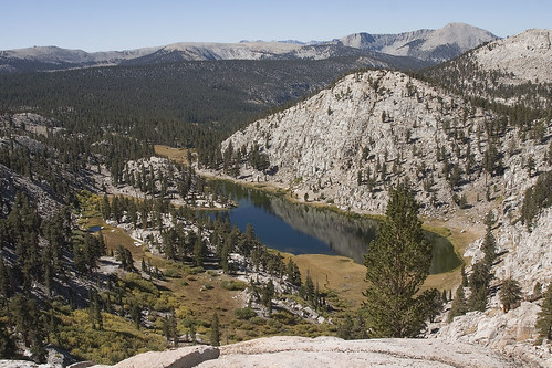
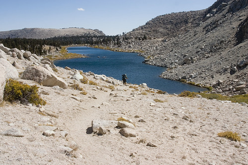
9-20-08, Day Three: Horseshoe Meadow to High Lake, 7.7 mi, +1752'
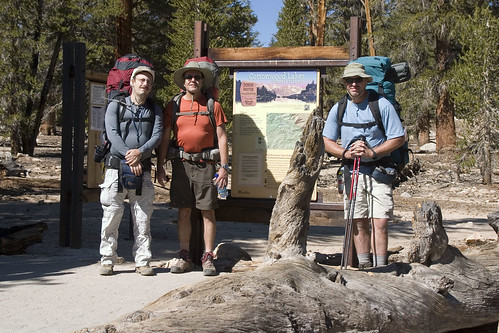
The next morning we broke camp, made sure everything was cleaned up, put our extra gear & clothes into Rob's car, and headed out. Of course, we had to stop for the obligatory trailhead shot. The Gorillapod came in handy again! If you notice, I'm wearing long sleeves. I brought long sleeve compression shirts, and surprisingly the long sleeves actually helped. Not only did my arms not get sunburned, but they felt cooler because I wasn't feeling the sun directly on them while the air was blowing through the shirt.
Of course, we had already seen the first 3.5 miles the previous day, so I didn't duplicate the photos. Just after the Inyo sign and just before the main elevation gain, we stopped for a snack.
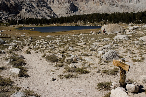
Following the guidebook closely, at every trail junction we followed the signs for New Army Pass. New Army Pass was directly above High Lake, our destination for the day. The first lake we came across was the first of the Cottonwood Lakes, the unoriginally named Cottonwood Lake #1. This was our lunch spot.
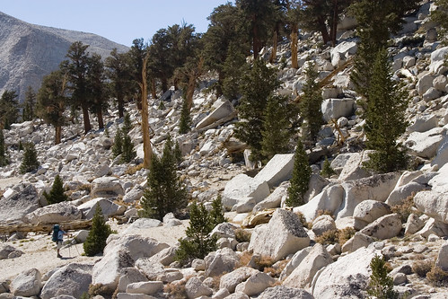
Just beyond the Cottonwood Lakes, we hiked through a boulder field. Those aren't just small rocks, they're boulders the size of trucks.
To give you some idea of their size, Bob is on the left.
After hiking around the Cottonwood Lakes for an hour or so, we came out next to a creek and what looked like the most gorgeous campsite you would ever see. Being about 30 feet from the creek, that eliminated the possibility, but the Forest Service really wanted us to know that we shouldn't camp there. Fine, we won't camp there.
Instead, we camped a bit closer to the lake itself, in a campsite that was much better, in my opinion. There were plenty of rocks for cooking and gear storage, with a nice view of the approach to New Army Pass. Once we got set up, I decided to scope out a good position for some sunset photography. I don't think we could have asked for a better spot.
Rob & Bob decided to go for a swim, and called it their "bath". They tried to get me into the water, but that lake was COLD! Rob's watch read 45 degrees.
After the swim, we all ate dinner. As sunset approached, I climbed back onto my perch and took some pictures with the Gorillapod. At $50, barely weighing anything, this was probably my personal favorite gear of the trip. In the past I've carried my normal tripod that weighs at about 8 pounds, so believe me, I was quite thankful for the Gorilla!
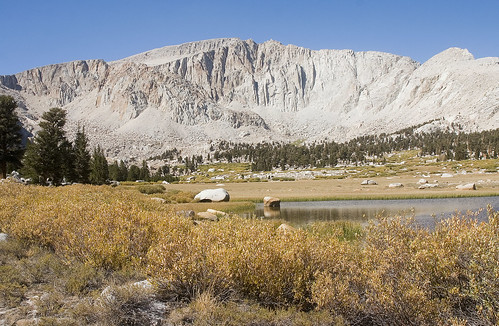
Originally we had wanted to climb Cirque Peak, which we could see from our campsite. Unfortunately, the time we got there and all the camp chores necessary made it something we'd have to save for another time. That's okay. Here's a view of Cirque Peak, at sunset.
Being at over 11,000 feet, combined with lying on my belly to take the pictures really gave my head a good throbbing. I came back down around 8:30pm and pretty much went straight to bed. Rob tried to get me to stay up and visit, but my head just didn't want to cooperate. In the morning, I was extremely happy I went to bed early, since my headache was all but gone.
9-21-08, Day Four: High Lake to Mt. Langley to Upper Soldier Lake, 9 miles, +3104'
This was the day that really made us start to think that yeah, all the time and effort put into training was coming in handy. Looking at the Google Earth rendering of our trail it's pretty clear: this day was all about the word "uphill".
The elevation gain was really divided in half. The first half was going up New Army Pass.
Heading up the pass, we could see back at our former campsite, High Lake, and the Cottonwood Lakes.
After almost exactly one hour, we made it to the top of the pass.
The views were incredible from up there! You could see Mt. Langley, Mt. Muir, Mt. Whitney, and others. Langley was an imposing figure, to be sure. As I found out early on with my Canon 10D, my wide angle lens isn't really all that wide when used on a DSLR with an APS-sized sensor. So what can a guy do? A panorama in Photoshop, of course! Make sure to click on this image, View All Sizes, and view the actual size of this one. Mt. Langley is on the right.
We spent a good half hour exploring New Army Pass. We could easily have spent a few hours up there.
After gearing back up, we headed towards Mt. Langley, which became the second half of our elevation gain for the day.
Per our guidebook, we followed the New Army Pass trail until we saw a wash, which we followed around to a use trail that headed towards Langley. Along the way we came across two fellow hikers who were descending the mountain, and gave us some idea of what to expect. Basically there is no official trail going up to Langley, but there are hundreds of use trails. The use trails get created because really the mountain leading up to the peak is scree, which moves and slides as people walk on it. The trails reminded me of footpaths in slow, coming and going with time. We left our packs behind a large boulder, filled our daypacks with lunch and water, and headed up. I managed to attach the 10D to the pack via a few carbiners, leaving the bag to bounce as I hiked. It wasn't going to be a very long hike, so I figured it'd be okay.
After spending what seemed an eternity climbing up the steep scree slope, we scaled what amounted to 1/4 mile of boulders to reach the summit. Bob found it first, and when we got to the top, he was sitting right on top of the marker. Rob also had to stand on top of the marker, but I was happy with sitting on it.
I set up the camera on the Gorillapod, used the remote trigger, got myself onto the rock and, *SNAP*, we had our hero shot.
Once again, the views from the top were incredible. From this angle, we could easily see Muir & Whitney, our destination for the next day. Whitney is the highest peak in view.
I couldn't resist the temptation and lie down on my stomach, pointing the camera off the edge, for a view down the cliff. This doesn't do it justice.
I also couldn't resist this one. I put the GPS next to the marker and took a picture of them together. The Garmin was 28 feet off from the marker's elevation. Which one was inaccurate? Who knows.
Here's a good rendition of our ascent from the opposite (cliff) side of Langley, looking back at the path.
On the way back down, I noticed the camera bag was starting to bounce and hit my legs as I hiked. This was a little strange, since it was supposed to be up by my back, so I adjusted the straps and continued on. At one point Rob was behind me and said hey, your pack's open. Of course, I had zipped it up at the top. What happened was the weight of the camera pulled down, causing the zipper to come undone and just open up. Rob caught it as my cell phone landed on the ground, but guess what was missing from the pack?
The Gorillapod. My favorite piece of gear from the trip had been lost somewhere in the quarter-mile descent from the peak! Using the GPS to backtrack, I had hoped to find it somewhere along the line, but it was obvious once I got back to the peak itself that it was gone. *snif*
Back at the boulder, we took a quick snack & water break, geared back up, and made the descent down to Upper Soldier Lake. Once again, it was a gruelling trip, only this time downhill. According to National Geographic TOPO, the elevation loss was 3404', which was more than our gain for the day.
At Upper Soldier Lake, we were treated to a campsite that was better than even the last one. We were back at a lower elevation, so we had TREES! The lake was surrounded by a beautiful marsh and the site itself could probably have held an entire Boy Scout Troop. It was HUGE, with the Major General imposing above us. There was a wide view of the sky, which once darkness came, was full of stars. The site was so large it was almost like being on a private beach.
We set up camp quickly because we were losing light fast. I filled Rob's bucket with water and we had dinner. This night I stayed up quite a while longer, and we planned the next day, which was to be the day we would summit Whitney. Little did we know, this would not be the case.
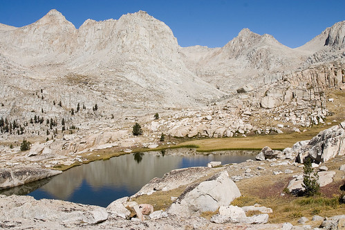
9-22-08, Day Five: Upper Soldier Lake to just above Sky Blue Lake to Rock Creek, 8.5 miles, +1370', -1948'
Our morning was an extremely casual one because our goal was to get to Sky Blue Lake, climb the pass, and camp somewhere on the ridge. Mileage was to be short, about the distance of our trip to High Lake, at about 5 or 6 miles. We took our time eating breakfast, and afterwards I took a short hike alongside Upper Soldier Lake for some pictures. At that time of the morning, the lighting combined with the stillness of the lake made for some amazing reflections.
I hiked a little farther and got just above Lower Soldier Lake, which was only about a quarter mile away.
The Major General was impressive from here as well, and the shadows being created by the rising sun was beautiful.
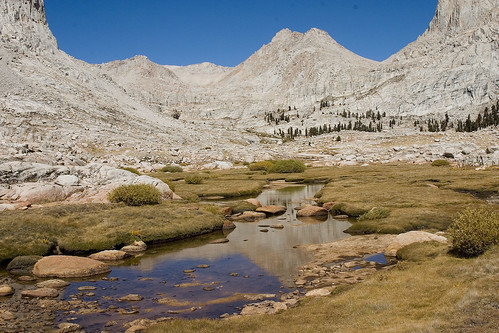
Once our gear was loaded once again, we headed off, this time cross country. Basically we skirted the base of the Major General, then around the side. Once we rounded the bend, we caught a great view.
At the end of the bend, we needed to move towards an "unseen notch". What's an unseen notch? Actually it was just a notch in the landscape that we couldn't see until we were all the way around the bend. We had to climb down some rock and over the creek in order to get over there, where we found a use trail. The trail led up to a small tarn.
It was all beautiful country, but I think of all the areas we visited, the trip through the small canyon in the notch was my favorite.
At a certain point we kept finding what I can only describe as enormous steps. They weren't steps that you could climb, but it's always interesting to me how from a distance you can look at a mountain and see that instead of it being straight up, there are platforms as you travel. This one had probably 3 or 4 of these platforms. This was one of them.
As we hiked across what I described as a platform (really about 1/8 of a mile or so), we hiked along the creek, which was flowing down the length of the platform. Be sure to look at the larger version of this for the detail. Rob & Bob are hiking alongside the creek, which is forming a longish waterfall along the length of the trail.
At the top of this particular platform/shelf (it HAS to have a real name!) was Sky-Blue Lake. It really was blue. Really, really, really blue.
Someone had a tent among the rocks above the lake, so we hiked a bit further and found the perfect place for our lunch break.
Looking back towards the lake's outlet, you can see the dropoff where we climbed in.
Here's another view back to the outlet from the opposite side of Sky-Blue Lake.
Above Sky-Blue Lake, we were following the guidebook's instructions over Crabtree Pass, but things didn't quite add up. We actually had two versions of the guidebook ("Mount Whitney, The Complete Trailhead to Summit guide by Paul Richins"). While I don't have older version handy, I'll quote the new version.
"From Sky-Blue Lake's outlet, walk around the right (east and north) side and ascend alongside the lake's inlet stream, heading generally northwest and then angling west through beautiful meadows and past several small ponds. At a large glacial moraine and two potholes at 11,920 feet, the stream turns right (north). Follow the streambed over large boulders and talus to a tarn at 12,000 feet. At the upper end of this tarn and meadow, hike northeast up gradual terrain to the outlet of the large unnamed lake at 12,129 feet. From the outlet you can look down on Sky-Blue Lake and up to Crabtree Pass."
Right. We walked around the right side and ascended the inlet stream. We stayed northwest, then angled west. Our elevation changed, and we got to around 11,850 feet, but there was nothing. We were below 12,000 feet but certanly didn't see where there could be a tarn. Rob was telling us that we needed to ascend up back where we came from, so we headed back down a bit.
Back at our last turn, this was the only alternate route, not to the pass, but up to where we could see the pass.
If it looks like a cliff, that's because it is. We thought that maybe, just maybe, there was a trail leading up, so we dropped our packs while Bob went ahead to check it out. He started hiking, but as Rob and I watched, we saw him get down on all fours and start climbing. Bob wasn't wearing a pack and was still having some difficulty getting up.
There was no way Richins was talking about this! This was a cliff, but his wording never mentioned that word. In fact, earlier in the text he says, "It is an enjoyable hike to the pass, but it is over difficult terrain requiring a considerable amount of scrambling." Scrambling? Do you call this scrambling? Did he perhaps have a different defition of the word "scrambling"?
When Bob came down, he described it as high Class 2, maybe low Class 3. By the end of the trip he was calling it Class 4. In the end, we had to retreat and head towards Rock Creek, because we were losing light. Not only that, but we had lost the chance to summit Whitney the next day, and needed to make up as much mileage as we could to shorten the trip back the way we came, back to Rob's car. Shuttling Bob's truck to the Whitney Portal ended up being unnecessary. We made it to a good campsite just as the sun was setting. We had dinner, got lots of recovery drink and made it to bed after pouring over maps and the guidebooks. In the end, we all agreed that the place we were at before turning back towards the cliff was really the way we needed to go, and we were probably 2/10 of a mile from where we wanted to be. Hindsight is always everything, of course.
9-23-08, Day Six: Rock Creek to Army Pass to Horseshoe Meadow, 12 miles, +1721', -2345'
The next morning we awoke to frost on everything. My red backpack was reduced to a lame pink color seen through the frost.
The sun was slow at first, so Bob & Rob decided to climb to the sunlight to use the restroom. They ended up ascending what looked to be 70 or 80 feet! It was on the opposite side of the creek and up the hill.
The hike from Rock Creek down to the Army Pass Trail was pretty flat and much welcomed by me. Once we got close to the trail though, we started losing elevation quickly. On the Army Pass trail, we quickly gained the elevation back and then some as we approached the pass.
Once at the top of the pass it was much windier than New Army Pass had been the previous day. We could see New Army from where we were at, but when we came over the top, we saw our trail down. Army Pass is an unmaintained trail that's been bashed and beaten by rockslides for many, many years. And we were going down it!
Somehow I ended up leading the way. I refused to take pictures on the way down, I wanted to be focused on the task at hand.
Once at the the bottom we ran into an older gentleman on his way up. He didn't seem too worried about the pass, but we told him how it was for us anyway. I took a picture from our lunch spot, back up towards where we came down. Oddly enough, the angle's pretty close to the Google Earth image.
That lake is Cottonwood Lake #5, with its unique name and neat landscaping.
The trail led between #5 and #4, which came into view next.
Almost at Cottonwood Lake #1, where we had lunch on the first day, Bob told us to look back at where we came. We had a great alternate view of Mt. Langley with a meadow and lake in the foreground.
From here it was a pretty basic hike back, although as I've mentioned before I suffered from the "end of hike" thing where the last few miles seem to take forever. I'm sure it's 100% psychological, but here's something interesting: at one point we barely started to gain elevation when my heart rate jumped to the levels I'm at when I'm jogging. I'm talking 156 to 160bpm. I'm thinking it was simple fatigue, but it affected me quite heftily.
Back at Rob's car we fenagled our equipment and ourselves in and were making plans to shower and have a nice dinner, then a good night's sleep before heading home. Life, as always, had other plans.
When we got into cell phone range and were able to call the outside world, Rob got the news: his sister had passed away a few days prior, and there had been no way to contact us. This demanded his immediate attention, so he made the decision to head right back. He told his wife we were coming home around 5:30pm.
We gassed up the vehicles, grabbed a bite at Carl's Jr. and headed out. I stayed with Rob so I could keep him occupied during the 8+ hour trip home. We ended up stopping every half hour to an hour for Rob and Bob to get enough shut-eye to get along. With all the stops it was almost a 10-hour drive and once in town, Bob dropped me off at my house. I walked in the front door at 4:30am on Friday morning.
Even without summiting Whitney, the trip was a success. We climbed Mt. Langley, which tops out at over 14,000 feet, and in the process hiked 42 miles, 8291' of elevation gain, 8318' of loss, and burned roughly 24,000 calories. We also have an excuse to come back next year: Whitney 2009!
Subscribe to:
Posts (Atom)


