The Chances

How a 250+ Pound Couch Potato Got Healthy

Friday, September 19, 2008

Gearing Up For Whitney

We're getting down to the wire here. I assembled most of my pack tonight. I wanted to actually pack it, but the new Therm-a-Rest is taking a lot longer than I expected to self inflate. The instructions say to let it self inflate when you first unwrap it, then let it sit inflated overnight before packing it up. So that's what I'm doing.

Food! This is breakfast, lunch, and dinner for 5 days. The first day's food is in the plastic bags to the right, separated into breakfast, lunch, & dinner. Those meals don't need to be in the bear canister, as they'll be eaten before we go to bed. Food: 10 Powerbar Gels (2 per day), 3 servings of banana nut oatmeal, 5 cytomax packets, 5 clif shot hot apple cider, 4 instant puddings, freeze dried blueberries, dehydrated apples, dehydrated apricots, 4 clif bars, 4 protein brownies, 1 Big 100 chocolate chip cookie dough bar, 2 Mountain House breakfasts, 5 Mountain House dinners (chicken with noodles, beef stew, beef stroganoff, teriyaki chicken, 2 instant cheese mashed potato mixes, 3 cup-a-soups, 2 miso soups, and one big bag of trail mix that will be divvied up into separate trail-food bags later.


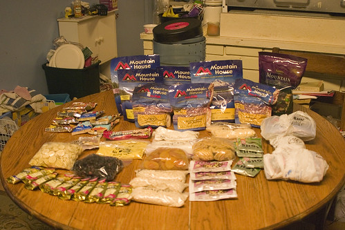
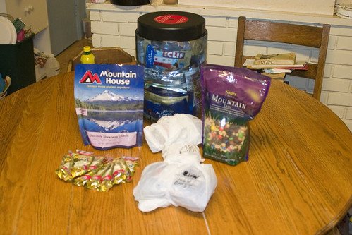
Tuesday through Friday's food is in the bear canister. Mountain House dessert + breakfast, lunch, & dinner for Monday are outside the canister, as is the gel and trail mix.


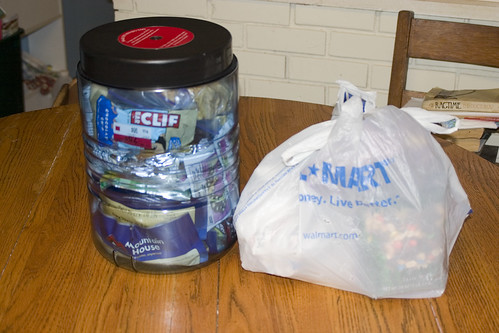
Monday's food & trail mix packed in one bag alongside the bear canister.


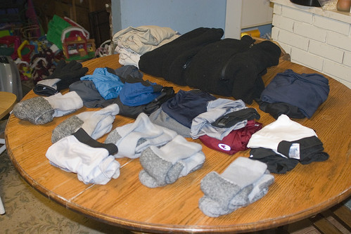
Clothes! Monday through Friday's socks, base layers (wicking underwear & wicking long sleeve shirts), midweight synthetic thermal underwear (top & bottom), fleece pants, fleece jacket, waterproof/breathable pant shell, spare pant shell, spare underwear, & spare socks. Not pictured: waterproof/breathable jacket.


Toiletries & personal grooming: Toilet paper, trowel, camp soap, purell hand cleanser, toothbrush, toothpaste, waterproof/breathable jacket.


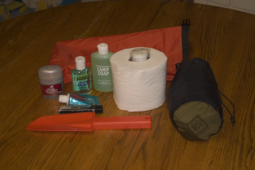
Personal stuff in a stuff sack + waterproof/breathable jacket.


Most of the essentials: sunscreen, medicated sunscreen lip balm, 2 LED headlamps, 1 LED lantern, waterproof matches, multitool, compass, iodine tablets, & hat.


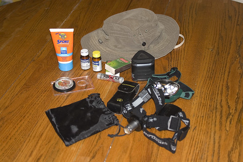
Gore-Tex hiking boots, camp shoes, 2 3-liter hydration bladders, water filter, mug, daypack, spork, nalgene bottle, & extra stuff sack. Oh yeah, and my new Gorillapod SLR-ZOOM. That's the alien-looking black & white thing you see. It's a portable tripod that weights next to nothing and wraps around things like trees and rocks.


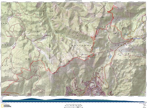
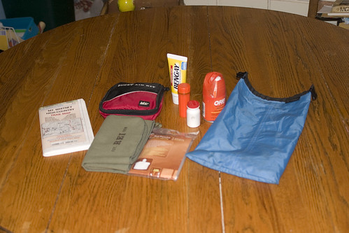
Mt. Whitney Zone trail map, First Aid kit, camp towel, disposable rain pancho, Ben Gay, ibuprofen, sudafed, & bug spray. I'll also be bringing a larger 24k trail map that I printed & had laminated. The first aid kit will likely be scrapped because we need a bigger one that will be shared among the three of us.


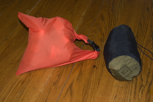
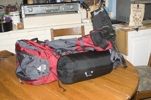
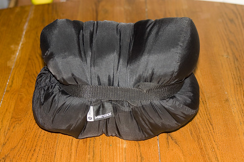
Gregory Palisade backpack & Marmot Sawtooth sleeping bag in its stuff sack.


A friend from work taught me this trick, the sleeping bag takes up about half its packed size if you squish it with your knee, then secure with a compression strap.


Not pictured were the Therm-a-Rest of course, spare batteries, and some reading material. This will be the longest trip I've been on; prior to this, I've only stayed overnight.

Wednesday, September 17, 2008

Wow, I haven't blogged since Friday. Heh.

I'm still getting everything together for the Whitney trip. We leave on Monday, and I want to have everything ready to go so I'm not all stressed out. On Saturday I went to the Folsom REI gear sale and they had more stuff than I've seen at any gear sale to date. But did I find anything that I wanted or needed? Nope. My wife found some shoes & boots for the kids, and Gregory got a marshmallow gun, but that was it.

I still needed more food for the trip, so I picked up a couple more Mountain House meals. With the Folsom store being so small, I decided to drive over to the Sacramento REI to pick up my synthetic thermal underwear. Come to find out, the construction on the store has made them reduce their inventory, and they didn't have anything in my size! So I drove to the Roseville store.

On the way through Roseville, I stopped off at Trader Joe's and got a dried fruit for the trip, as well as a cheese roll stuffed with ham and a loaf of dense bread. Good, good stuff. At REI, I picked up the thermal underwear.

Then today at lunchI ran 5.5 miles. I am just *loving* the weather lately! The high today's supposed to be 79, and while I was running it was a mere 64. 64 degrees!

I ran to the gym (3.25 miles, something like that), then did some weights in supersets of two:

1A: Bench Press, 3 sets of 6, 115lbs
1B: Dumbbell Curls, 3 sets of 6, 25lb dumbbells
2A: Chin-ups, 1 set of 2, 2 sets of 1
3A: Dumbbell Shoulder Press, 3 sets of 10, 25lb dumbbells
3B: Reverse Crunches, 3 sets of 10

Afterwards I ran the rest of the loop back to work, a little under 3 miles. I stopped the GPS timer when I stopped at the gym, then started it once I left again for accuracy. 50:18.79 for the loop, 9:13/mi which is almost :45 better than my last couple. I only worked the weights for 10 minutes. 726 total calories burned.

Friday, September 12, 2008

Today was another great run! Once again traffic wasn't cooperative. It has to be my timing coming up and going down the overpasses, but I always end up with 20 cars going onto the freeway whenever I need to cross! So I have to stop for sometimes 30 seconds or more for them, it sucks. At any rate, my pace was exactly the same as the other day, and my time was one second faster. And to top it off, I didn't feel like I did yesterday, which is great, hehe.

Most interestingly, the HRM and the GPS were IDENTICAL for calories burned: 690. I have no idea how that happened, the GPS is time & distance only. I suppose it's accurate at this point.

So anyway, 5.5 miles, 52 minutes, 690 calories burned.
Hey guys, I finally got around to trying out geotagging. It took some serious research to find the tools! It's still obscure for some reason.

A quick bit of background, part of the reason I took my Canon 10D with me on the last segment of the Tahoe Rim Trail was geotagging. I wanted to get the process down so when I take my trip to Mt. Whitney, I can have the pictures, with the GPS track, geotagged in Flickr, and mapped onto Google Earth. I haven't taken it to Google Earth yet.

So anyway, I took the pictures, and have the resulting jpegs in a folder. You can do this with the RAW files, but since I already had the jpegs on Flickr, I started there.

After lots of research I found a program called Geosetter. It works WONDERFULLY. When I put the .gpx file into the same folder as the images, once I clicked on the folder holding the images, it knew to use that file. It then was able to interpolate the data based on EXIF dates, and finally save the GPS data to the EXIF of the images.

Finally, I replaced the images already on Flickr with the updated ones. The process would have been a lot quicker had they not already been on Flickr, I could have just done one upload. You do need to tell Flickr that yes, you want to automatically map EXIF information.

Once I did that, the images were mapped within Flickr. Each image shows its city location, and a link to Map, which when clicked, shows the image on a map. Since this was backcountry hiking, I had to turn on the Satellite map. Here's a sample:


The rest of the images from that hike are here.

I apologize for not all the files being geotagged, but the images not taken by me didn't have timestamps. It seemed to work out pretty well! Not being a Picasa user, I'm not sure how it handles the images, but Flickr seemed to work out well.

I'll be geotagging a lot more images, as well as doing it for all the pictures from my upcoming Mt. Whitney trip.

Tuesday, September 09, 2008

It's AMAZING what a little cooler weather can do. Today it was a cool 63 degrees during my run, very abnormal for 10:30 on an early September day. For example, last week it was 80 when I went out. At any rate, I had the best run I've had in WEEKS.

Everything was better. My breathing was great, I wasn't fatigued, I felt like I could go on forever. The weather was awesome, my pace, while not my best, certainly was better than it's been. Well, you've heard me whining that my average has been more like 11 min/mile lately.

My pace was 9:42! That's the best it's been since before my bout with chest congestion, which was a few months ago now. Seriously, I did 5.25 miles in 52 minutes. And afterwards? I feel great!

While not accurate (I wasn't wearing the strap today), the GPS estimates 690 calories burned.

Anyway, I'm glad it was a nice day today.

Monday, September 08, 2008

The Tahoe Rim Trail is a trail that goes 165 miles around the perimeter of Lake Tahoe in California & Nevada. They have it separated into 8 sections so you can finish it without having to do the entire trail at once.

With the hike I did on Saturday, I've now completed all 165 miles! I had wanted to complete it last year, but my mother's illness made that impossible. I mentioned this to the TRT Association person on the phone, and she said, "Some people take ten years!" I found that funny, since the trail was only completed in 2001. :)


* 5-20-07 | 12.2 mi | Spooner Summit to Kingsbury Grade | Blog | Gallery
* 7-15-07 | 22.8 mi | Kingsbury Grade to Big Meadows | Blog | Gallery
* 7-29-07 | 17.5 mi | Big Meadows to Echo Lakes | Blog | Gallery
* 8-26-07 | 16.7 mi | Barker Pass to Tahoe City | Blog" | Gallery
* 9-8-07 & 9-9-07 (overnight) | 32.5 mi | Echo Lake to Barker Pass | Blog | Gallery1 | Gallery2
* 9-22-07 (snowed out) | 23.1 mi | Tahoe Meadows to Spooner Summit | No Blog | Gallery
* 8-16-08 | 23.1 mi | Tahoe Meadows to Spooner Summit | No Blog | Gallery
* 8-30-08 | 18.9 mi | Brockway Summit to Tahoe Meadows | Blog | Gallery
* 9-6-08 | 19.2 mi | Tahoe City to Brockway Summit | Blog | Gallery

A couple of the hikes varied slightly from the postings. Brockway Summit to Tahoe Meadows, for instance, we climbed Mt. Rose, which added 5 miles to the total.

I'm now a member of the 165 Mile Club, and eagerly await my certificate. Next up: Mt. Whitney in two weeks! Woo!
Saturday was my final Tahoe Rim Trail hike. That's right, I've now completed all 165 miles! For a while now I've not brought my DSLR because it's so big, but I also didn't have any pictures. This time, I decided to bring it and deal with the extra weight.

I played around, trying to attach the camera bag to myself. It's amazing with a bag that size, it's a game because you have to have the camera accessible or you won't use it, but the camera's so big, it gets in the way of mobility. I attached it to the pack's waist belt, and latched it so it wouldn't swing around. It worked surprisingly well, although it still got in the way of my left leg a bit.

So, yes, I'm back! I slept in until 10:30 yesterday morning, and enjoyed every minute. My wife told me she's glad I finished the TRT, that the day after I'm always grouchy and sore. Hmmph!


Like the last one, this one had views of Lake Tahoe for quite a while. In fact, as we started there was a great view as we ascended.


Here's a quick Google Earth view of the entire trail, this one according to the trail posting was 19.2 miles. At the end, the GPS showed 19.5 miles, but National Geographic TOPO! only showed 18.86. Well, close enough.


Also unlike many of the segments, this one wasn't stuck under trees the whole time, we could actually see quite a bit. The person who took this picture managed to get my gut in the sun. Thanks.


About 13 miles in there was a nice lake we got to relax by. Believe me, we relaxed. A couple people swam.


So that's it, everyone, I've completed the 165-mile Tahoe Rim Trail. This is the end-of-trail kiosk. There's one at every trailhead and trail-end.


Finally, the whole group, tired from hiking and awaiting food.


A little later I'll post an overview of the entire Tahoe Rim Trail.

Friday, September 05, 2008

I actually felt well enough to try jogging yesterday. I kept the pace slow, 11 min/mile, and it went pretty good. I had to stop after 4.5 miles though, I was starting to have indigestion and I didn't want it to progress to the next level. Then this morning, I woke up at 160 pounds. I guess if I'm going to get something out of being sick, weight loss is a good thing to have!

No workout today, I'm going to REI at lunch. The final TRT hike is tomorrow.

Thursday, September 04, 2008

Hello, everyone. I've been posting here and there but haven't had a chance to explain what's been going on with me the past few days.

Saturday I did my TRT hike. Sunday I was tired, no more than usual after a long hike. The same with Monday during the day. I found out Monday that my son has tapeworm, so he had to be home from school a few days.

Monday afternoon we went to Sam's Club & Walmart, did some shopping for my mom, then came home. On the way to our house, we saw the fire aircraft overhead, and when we got to our street, we were told there was a mandatory evacuation and we had to get ready to leave as quickly as possible.

We went to my in-laws house, which is about 10 miles from where we live. Halfway there, my son said, "What's that smell? It smells like throw-up." We didn't smell anything, but just then my 2-year-old daughter threw up ALL over the backseat. We were lucky in the fact that we were right next to Mervyn's, so I went in and bought a big towel to mop up the mess. Once cleaned up, we drove the rest of the way to my in-laws.

She seemed to be doing better, so we put the kids to bed while I checked out the online news about the evacuation. By 8:15 they were letting people back home, but because the kids were down we decided to stay put. My wife and I went to bed. The next morning I found out that both girls (2 & 4) were throwing up all night and my wife and both in-laws were up and down with them. I was completely unaware this had happened, I guess I was pretty out of it.

Thing is, I had an unusually hard time opening my eyes. In fact while getting ready and driving to work, I felt like I just couldn't break out of sleep. My stomach was also a bit woozy. Once at work, I started feeling progressively worse. I felt like I was going to have diarhea, felt like I'd vomit, but never did. I was sweating like crazy and at one point I even asked someone what the temp was. I was definitely going to head home, but had an outstanding issue here at work that needed to be resolved first. I went into the restroom.

I tried to go but it didn't happen. The sweating got worse and was getting unbearable. I put my head back to lean up against the wall.

I woke up on the floor. The strange thing is, I didn't question it. My only thought was that I'd better get up, because people would see me under the stall with my pants down, and that would be silly. I got back onto the toilet and wiped the sweat off my face. There was a bit of blood, but again for some reason I didn't question it. After a minute or so I went into the break room where there's a cot, and lie down there for about 10 minutes.

I went back to my office to find the situation had sort of resolved itself, so I decided to head home. I basically lay down on the couch for two hours until my wife got home. When I went into the restroom, I noticed a cut on my forehead and found that I had a bump. It's obvious that I passed out. I'm still in a quandry as to why I didn't question being on the floor! I think I figured that I had lay down there, but come on... why would I lie down, pants around my legs, on the nasty restroom-stall floor where people could see me underneath the barrier? Right.

I rode out the rest of the evening and we finally all went to bed. Yesterday morning I got dressed and headed to work as usual, although my stomach was still a bit upset. I called my wife to check on the kids, only to find that she now had what I had but worse. She was both vomiting and had diarhea, and with my son having tapeworm and being home, she had all three kids to take care of. I told her I'd come home and help.

So I took the kids to McDonald's for lunch (a rarity), then to the park. I found I couldn't really play with them much because my stomach was still a bit upset. Anyway this got the kids away for a few hours so my wife could rest.

Fastforward to last night, my wife was still having stomach pain but was doing much better. My son kept saying he felt like he was going to throw up and sure enough, he started around 7:30. He was sick all night.

This morning my wife is feeling better. I'm finally 100%, and may give running a go in a little bit. My son hasn't thrown up all morning.

So anyway guys, that's my three days. How you been?

Monday, September 01, 2008

Alright, boys & girls, I'm finally all rested up. Actually I also had to get all my materials together to post about it. So our trip...

If you click the image it'll take you to Flickr, where you can see the full sized view of the topo map for the trip.


We actually made REALLY good time driving up to Tahoe, and the Brockway Summit trailhead came up faster than I expected. It was probably the shortest drive to any of the TRT hikes I've had. We left my car here and drove onto the Mt. Rose plaza in Bob's car.

A bit about TRT logistics. Each hike is one way, and there's not a shuttle between trailheads, so you have to have at least two cars. When hiking with the Meetup group we always have plenty of people, but in our case with two people, we just had to drive up to Tahoe separately.

Anyway, we were actually moving on the trail around 8am. My original plan was to, at the end of the trail after we'd come back for Bob's car, to hike to Mt. Rose then. That would give us a chance to look at how we felt after hiking, in case we didn't want to continue. Since we had such a good start, we decided to go ahead and do Mt. Rose first. My apology for the lack of real pictures.


The wind, the wind, the wind! It was tough walking around up there, but the view was great. We could see Reno, which is like 30 or 40 miles away. It helps that Reno has all the casinos or it'd just be some nondescript town. We spent all of about 5 minutes up there.


We headed down off Mt. Rose and took the connector trail from the Mt. Rose, .7 miles back to the TRT. Then we got to climb up all over again to the top of Relay Peak!


At this point I think we'd hiked about 6 miles, that sign says Brockway Summit is 15 miles. The views at this point were getting better and better, as we came across the ridges and finally in full view of Lake Tahoe, which went on for at least half of the hike, maybe more. BTW, I promise next time around I'm bringing my DSLR. These pictures suck.


As I said earlier, the trail went on along the ridge. At one point we needed water, but the only spot with available water was Mud Lake, which was down a bowl from the trail. We really had no choice, which added another 120 feet of elevation loss/gain. Once back on the trail, we came out onto the ridge again.


Past the ridge, we descended down into a more forested area, where we hiked the last 7 miles or so. We ran into a few backpackers, who were asking us where to find water, and who told us about how much farther we had to the end. From that point on the trail was mostly downhill, which made the going much, much faster.


Back at the car, the GPS said we'd gone about 24 miles. Back home in the National Geographic TOPO! software, it turned out to be 23.86 miles. Elevation gain +4920, max elevation 10,776'. Calories burned: 5055!